fbpx

Leaving Florida for Subarctic Alaska

One of the two trains

Leaving Florida, the white officers of the segregated 97th Engineering Regiment knew they headed from the Sunshine State to extended duty in subarctic Alaska.  Few of the 1200 young black soldiers who worked for them knew their destination or what lay in store. For them a transcontinental train ride meant exciting adventure.

At Eglin Field they dutifully packed their barracks bags and piled into the back of trucks. The trucks carried them to Pensacola where they boarded two waiting troop trains. The trains pulled out of springtime Pensacola on April 15, 1942, headed west.

White Civilians Meet Black Soldiers in Alaska

Most of the young soldiers had grown up in small towns in the Carolinas and Georgia and the stringent rules of Jim Crow had afforded few opportunities to see the world outside those towns. Now they travelled the width of the American continent.

Looking out the window

They crossed the Mississippi at Memphis, Tennessee and reached St. Louis on April 16. The next day they passed Kansas City and then pulled into Dodge City.

A 1939 Hollywood movie starring Errol Flynn had made Dodge City famous as the epicenter of the historic Wild West. Captain Walter Parsons, in charge of one of the two trains, remembered, “…since some of the boys had seen the picture show about the place, they got a big kick out of being there.”

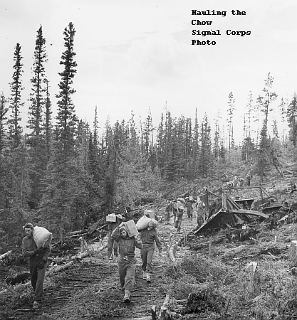
A day later, in Leadville, Colorado, the trains ran into snow, and Parsons remembered, “They opened all the windows they could and let the snow blow in… They had snowball fights. It was the first time some of these boys had seen snow.”

They would soon see a whole lot more of it.

Leaving Colorado and moving on into a Utah desert, the trains stopped for a time and some of the men got down to stretch their legs. A sandstorm blew in and they climbed back aboard in a hurry.

The trains passed through Idaho and then Oregon on the 19th. And they reached their destination at Fort Lewis, Washington on April 20, 1942—just five days out of Pensacola.

Plans and movement orders for a regiment always look good on paper. Reality at the Port of Seattle looked quite different. Wartime logistical chaos prevailed and promised personal equipment for the soldiers—sleeping bags, winter clothing, cold weather gear—had not arrived yet.

Up against a brutal schedule, the regiment could not wait. They would head out into the North Pacific and then through plunging temperatures up the inside passage to a Valdez, Alaska still locked in winter. They would just have to hope the equipment caught up.

One company, 160 soldiers, moved directly from Fort Lewis to the Seattle Port of Embarkation and moved their few trucks off the trains. Loading them onto the deck of the troopship USS David Branch, they chained them down on the deck. Through the day on April 22, the rest of the regiment moved to the port and crammed their 1,200 bodies and barracks bags into the fetid hold.

In the Hold of the troopship

The David Branch headed out into Puget Sound in the evening on April 22.

The David Branch

You know about Florida. Stand by for Valdez, Alaska.

Malodorous Canvas

As organized as any camp ever got.

Malodorous Canvas supported life in bivouac on the Alaska Highway in 1942. Tents provided barracks, mess halls and offices.  Men slept on folding canvas cots.  Canvas “lister bags” stored treated drinking water.  Canvas enclosures became mechanical repair shops.  In malodorous canvas enclosures, soldiers transformed empty fuel drums into stoves, showers and bath tubs.

Bivouac in the Woods

A company bivouac featured a headquarters tent– for the commander, his first sergeant and clerk–along with a mess hall and kitchen tent and numerous five man sleeping tents for the men.

Typical small bivouac in the woods

Bivouacs moved frequently, following the work, so tents, usually tied to trees, scattered informally.  Army field manual descriptions rarely applied—except in the case of latrines.  Troops located and prepared these critical facilities–twelve feet long, eighteen inches wide and six feet deep—with care.

Regimental headquarters and the H&S Company travelled with generators.  Company bivouacs made do with lanterns.  The orderly room might have one.  The mess tent, larger, might have five. The supply tent would have one. And officer’s tents would have one apiece. Enlisted men undressed, slept, and dressed in the dark.

This was a kitchen–cooks worked there

A typical kitchen tent came equipped with four white gas ranges and a fifty-five-gallon galvanized “dishwasher”. A large open tub, the dishwasher used a submersible heater which, given enough time, heated the water so men could come by and clean their mess kits. Joseph Prejean who worked in one of those kitchens remembered having to start the white gas burner by throwing gas on it.

The Corps of Engineers did not have to answer to OSHA.

Vintage Appliances–white gas stoves

Rough Draft of a Highway

A rough draft if you ever saw one.

Rough draft or not, the Army proposed to use its new Alaska Highway. Cpl. Gronke and Pvt. Bowie had thrilled reporters and their readers by driving its length in a half-ton weapons carrier. The convoys of 2 ½-ton cargo trucks that followed got far less attention.

Awards, Celebrations and Giving a Damn

Gronke and Bowie pass dignitaries on the first trip

A good thing for the Army’s Public Relations people.

Trainloads of brand new 2 ½-ton cargo trucks pulled into the depot at Dawson Creek—1700 of them–ready to take on the rough draft Alaska Highway. Drivers and mechanics from engineer units along the Highway set up a convoy system. Experienced engineers, not experienced truck drivers, they struggled. Wrecked and broken trucks outnumbered trucks arriving in Fairbanks.

The Army had a lot to learn about operating and maintaining trucks in bitter subarctic cold. The young drivers had a lot to learn about driving the rough grades in snow and ice. And ice washed bridges and culverts away faster than the soldiers could rebuild them.

On a good day…

Billy Connor, a civil engineer, remembered the greatest danger in travelling the pioneer road.   “If your vehicle breaks down, walking a few miles can actually cost you your life”. And the extreme cold increased the probability of a breakdown.

Beyond the danger of frost bite and freezing to death, the treacherous winter road caused wrecks that killed and maimed.  Relatively good traction, in severe cold, disappeared when temperatures warmed toward freezing.  “I have seen tools, chains, men and even trucks sliding down [a hill] faster than a man could run.”

A good stretch…

A soldier’s truck did not usually kill or maim him; but, sooner or later, it would roll to the side of the road and refuse to continue.  Truckers carried motley collections of scrounged tires and spare parts, and they actually made major repairs on motors, transmissions and rear ends alongside of the road.

Driving it in Winter Today

South Canol Rest Area

This gets your attention

South Canol Rest Area looks like a normal roadside rest area, but on the Alaska Highway you know better than to expect normal. In this rest area you park among a collection of incredibly old, very rusty, and exceedingly cool abandoned cars and trucks.

Driving north through Yukon Territory, between Teslin and Whitehorse, you cross the Teslin River Bridge, pass the Johnson’s Crossing Lodge; and, spotting the abandoned vehicles, you pull off to check them out.

Looking Closer

An old dirt road wanders away from the parking area—and away from the Highway. A big sign warns anybody who might be tempted to follow it “No Services Next 225 km”. An older, more weathered sign explains that you are looking at mile zero of the Canol Road.

Irony and History

Road with a warning attached
The Explanation

Even before Pearl Harbor, Canada built a string of airfields they called The Northwest Staging Route to fly supplies north to Alaska. After Pearl Harbor, the United States Army built the Alaska Highway along the same route. It occurred to senior commanders in Washington that they needed a source of fuel and lubricants for planes and trucks along that route.

Norman Wells, 513 miles (825 km) north on the Mackenzie River offered a source of crude oil, and in 1943 the Army initiated the Canol (Canadian Oil) Project. They scrounged refinery components from Texas and elsewhere and assembled them in Whitehorse. And they dispatched construction crews to install a pipeline and a service road north from the refinery to Norman Wells.

As usual the generals thoroughly underestimated the impact of terrain and climate on the effort. Soldiers and civilian contractors did their best, but both the pipeline and the road fell well short of state of the art. And the generals paid no attention to finances. By early 1944 when oil first flowed through the pipeline, the Canol Project had cost five times its budget.

In early 1944 a senate committee led by future president Harry Truman investigated and turned the Canol Project into a serious embarrassment for the Army. In 1945, fittingly enough on April 1, the Army abruptly shut down the pipeline and closed the refinery.

Abandoning the Canol Road, they also abandoned vehicles and equipment. And some of it still sits at Mile Zero—The South Canol Rest Area.

More on Canol from Explorenorth

Spinning Steel

I guess you got used to that blade

Spinning steel blades shrieked as they sliced through trees harvested along the path of the Alaska Highway. Men stood above and behind the blades, pulling levers, guiding the logs through, and the spinning blades helped roaring trucks and dozers demolish the quiet of the deep north woods. Sawyers proved as essential to the massive project as catskinners, truck drivers and axe men.

The soldiers built bridges of timber, driving pilings every twenty feet or so and spanning them with timber stringers. Across the stringers they laid planks, decking, for the roadbed. They also built barges to get across rivers too big to bridge—barges made of planks.

Timber Bridges

In the early weeks of the project, men fashioned planks with two-man handsaws and axes. But culvert, bridge, and barge builders consumed enormous quantities of lumber. Up in Alaska, soldiers of the 97th found an old sawmill along the way and quickly put it in operation. And the Army brought in bigger sawmills as quickly as they could. In the end the 97th set up a sawmill near Mentasta pass and assigned one whole company to run it.

Sawmills grew as the need grew

Civilian contractors building bridges at northernmost end of the Highway had their own sawmill, but it couldn’t keep up… They raided a collapsed bridge near Chitina to salvage its timbers.

Down in Yukon by mid-summer two regiments—the 340th and the 93rd worked south toward the continental divide. The 93rd stationed a company to run a sawmill near Morley Lake.

Almost Permanent

The soldiers of the 97th worked into an Alaska winter to complete the last section of the Highway. And then the Army scattered them along the way to keep the Highway open for convoys. Facing a winter in tents, the 97th found a new use for its sawyer soldiers—turning out lumber for rough barracks.

Old Time Sawmill on Youtube

Since 1942


This work is on the road from Carcross to Skagway but it illustrates the process

Since 1942 thousands of men and two governments have struggled to complete the Alaska Highway. It hasn’t happened yet.

In the summer of 2017, men and heavy equipment worked over several miles of the Highway north of Kluane Lake. Waiting for their turn to pass through the construction zone, some drivers got out to stretch their legs. One of them asked the flag man how long they had been working on this stretch. His answer said it all.

“Since 1942”

Grading near Kluane Lake

The road builders in 1942 fought geography and climate for every single mile, and the road they built stands as an epic achievement. But the geography and climate of Northern Canada and Alaska didn’t go away when the soldiers did. When civilian contractors showed up in 1943 to rebuild bridges and widen and straighten the road, they fought geography and climate just as the soldiers had.

Extreme Geography

They left the road improved but still only convoys of vehicles accompanied by wreckers used it—very carefully.

Way better equipment

The 1942 agreement with the Canadian government that allowed the United States to build the Highway specified they would turn it over to Canada after the war. Contractors, working for the United States Public Roads Administration, kept improving and repairing until 1946. After that contractors fighting geography and climate worked for Canada’s government. The fight didn’t get any easier.

In 1948 Canada opened the Highway to limited civilian traffic. Civilians who drove the Highway may have found it uplifting and exhilarating, but they by no means found it easy.

One lady told us of her trip up the Highway with her husband and their infant daughter. She mounted a bucket full of soapy water to the front bumper of their car and tossed soiled diapers in as they travelled. The bumps in the road agitated the baby’s laundry as thoroughly as any washing machine.

Through the decades Canada has slowly but surely improved the Highway, and it offers a vastly different experience today. But the men who struggle to keep it in repair, know what the flag man knew.

Never Done

The geography and climate will never stop fighting back.

Yukon Territory has problems affording it

Muscle and Bone


Muscle at work

Muscle and bone and sheer determination were, by mid-summer tearing a long Alaska Highway out of the subarctic wilderness. By July from Dawson Creek, British Columbia to Tok, Alaska, against all odds, the Highway began to emerge, and the modern epic caught the attention of the outside world.

Reporters bestowed nicknames on the project. “The Tote Road”, The Pioneer Road”, “The Truck Trail”, “The Long Trail”, “The Oil Can Highway”, “The Burma Road of North America”.

The Oil Can Highway

The epic needed bulldozers, graders, trucks, barges, and a long list of other equipment. But in the end men operated the equipment, dragged it through or dug it out of the mud, fixed it when it broke. And, above all, men swarmed all around it, taking on the wilderness with muscle and bone and hand tools.

More muscle and bone

The sun shined twenty-two hours a day during summer, and commanders made full use of all that daylight. Soldiers worked hour after endless hour. Henry Geyer remembered simply. “You worked until you dropped.”

Chester Russell put it this way. “We was working so hard that by the time you got to the night, you rolled your sleeping bag out underneath a tree or in the bushes and you crawled in it and sacked out.”

Chester Russell

Pfc Fowler remembered more detail. “…We slept on the ground with two blankets and a mattress cover.  All of our extras, clothes, toilet items and writing things were kept in the mattress cover.” Early each morning the men rolled their stuff into bedrolls and loaded them in the back of a truck. Many long hours and a few miles further along when daylight finally went away, they dug their bedrolls out of the pile, unrolled them and promptly fell asleep. They did not waste time on tents or shelters.

Sometimes even their food took muscle

Stone Sheep

This is what I mean

Stone Sheep, the sight of one—or two or three—perched on a ledge on a high rock cliff above the Alaska Highway will bring your vehicle to the side of the road and your camera to your eye just as surely as the sight of a grizzly. They turn craggy heads with great curved horns. Their strangely delicate faces fix inquisitive eyes down on you.

You do not bother them. You would need pitons, ropes, time–and youth–to get to their ledge. Their slender fur patched bodies, on the other hand, can bound up and down the cliffside like squirrels run up and down a tree. Looking at them you really cannot picture that. But they rest on a tiny ledge a few hundred feet above you, and they got themselves there somehow.

Bears on the Alaska Highway

Family

Sheep populate the Alaska Highway right alongside the bears and the moose and the other magnificent creatures who call Northern Canada home. Not humble places, British Columbia and Yukon Territory do not host humble creatures. You can forget the simple, wool covered critter the word “sheep” brings to mind. The Alaska Highway presents Stone Sheep.

If you are not from there, you have not seen a creature like this before. According to the website “Discover the Outdoors”, they stand thirty-six to forty-two inches in height, and weigh between 125 and 200 pounds. They live on high mountains, usually above the timberline. The website

Graceful creature

Approximately 3,000 Stone Sheep populate the Canadian Rockies in Yukon and British Columbia, and they reproduce slowly. Ewes reach breeding age at three and have one lamb a year. Rams must wait until their horns get big enough to establish their dominance—seven to nine years.

Sadly, most of them never make it.

By the way, if you like my posts, consider clicking on the “be notified” button at the top of the page or the subscribe button at the upper left. You’ll get an email each time I post. On a phone click on the menu button at the upper left (three horizontal lines) the be notified button will drop down.


Timber Bridges

This bridge across Beaver Creek is typical

Timber bridges installed by Alaska Highway builders speeding through the subarctic region in the summer of 1942 survived their first winter. Well… some of them survived. The soldiers, forced to add building timber bridges to their rapidly expanding skill set, learned speed not quality.

North of Whitehorse, just forty soldiers built Jo-Jo River Bridge, forty five feet long, sixteen feet wide and about twelve feet above the river in ten hours.

This is how it started

The biggest rivers forced the soldiers to make do with barges. And they channeled thousands of small streams through culverts. But by the end of the summer hundreds of timber bridges spanned streams and rivers from Dawson Creek all the way to Big Delta.

Barge “Bridges”

Hinkle and Boyd’s Canyon

The soldiers felled trees and sawed them into logs. They built enclosures, dragged them into the icy water and placed them to form two parallel lines across the river. In each container they placed a vertical timber, packing the container full of rocks to hold the timber upright.

Progress

Atop the vertical timbers they constructed a flat platform of logs, and when a D8 Dozer drove out onto the platform it groaned and shook a bit. But it carried the weight. Bridge builders turned back into road builders and moved on to the next river.

Nearly Done

Then came winter—and mushroom ice.

Even the bitterest of bitter cold does not form ice in a swift moving current. Water continues to flow. But ice forms along the sides and the bottom of the flow, gradually compressing its channel, raising the water level. Ultimately water flows over and around a bridge. Great mounds of ice form and grow over the bridge and its approaches. In the spring, melting ice cracks and breaks up and moves. In 1943 moving mushroom ice often took its timber bridge along for the ride.

No matter. Civilians from the Public Roads Administration would be back in the summer of 1943 upgrading the bridges along with the Highway.

More on Alaska Highway Bridges

Glaciers

A frozen river

Glaciers. As you travel north, the first one you see tells you that you have well and truly reached the subarctic region. You can scratch that off your bucket list.

The Valdez Glacier

It is summer, but a vast sheet of ice covers all but the peaks of the mountains towering in front of you. Or maybe, instead of covering the mountains, the ice comes down between peaks on the left and peaks on the right and combines into a bigger sheet aimed down into a valley. Or maybe a long, slender blue-white river winds down a deep canyon—a river with no current except for the stream flowing out of its bottom.

Massive Ice Cover in Canada’s Jasper National Park

Massive and implacable, glaciers exist only here in this vast, beautiful, and unforgiving country. And this is their world. They belong. You exist here only as an awed spectator.

Rain and snow fall on the mountains and the water tries to flow downhill. In bitter subarctic cold, though, it freezes and over centuries of geologic time forms into glaciers. The water still makes its way down hill, but instead of flowing water, mountains of ice move at a pace that can only be called, well… glacial. You do not see them move. But they do.

One of Alaska’s most famous–Worthington

Glaciers slide, ever so slowly, grinding and abrading the rock beneath them into fine particles that permeate their ice. Every spring some of the ice on the front of the glacier melts and a massive flood cascades down, carrying particles of ground rock. As the water slows and fans out from the base of the glacier the particles fall out. Over the centuries they accumulate into a terminal moraine, a broad fan of finely ground rock sprawling out from the base of the glacier.

I took this photo, but I have no memory of where.

A Directory of Alaska’s Glaciers